Mount sabinyo hike, climbing mount sabyinyo volcano in Uganda
 Mount Sabinyo/Sabyinyo volcano is one of the Virunga Mountain volcanoes with others being Mount Gahinga, Muhabura, Karisimbi, Bisoke, Mikeno, Nyiragongo and Nyamuragira. Mount Sabinyo Volcano is the most spectacular and interesting of all the Virunga Volcanoes. It is a dormant volcano standing at an elevation of 3,645m ASL. Uganda’s share of Mount Sabinyo is in Mgahinga Gorilla National Park. Just like some of the other Virunga mountain ranges, Sabinyo is shared by 3 countries; Uganda, Rwanda and Congo.
Mount Sabinyo Volcano used to be a symmetrical-shaped but got torn apart by the violent explosions that left it with narrow ridges, deep canyons and steep faces. Also time has eroded Sabinyo’s jagged summit leaving it appear like an old man’s teeth when viewed at a distance. Sabinyo is a local Kinya-rwanda word meaning old man’s teeth. You will see an old man smiling at you when you view Sabinyo from afar.
Mount Sabinyo Volcano hike is only possible from the Uganda side. The many ridges, rugged slopes and craters, partly render navigation from the Congo and Rwanda sides impossible. Mgahinga Park authorities established handmade ladders which aid navigation through difficult areas of the trail! Sabinyo has 5 peaks but it’s only the 3 that can be reached by the hikers. Request a Quote
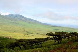
Climbing Mount Sabyinyo Volcano in Uganda
Mount Sabinyo Volcano has the most strenuous but yet rewarding hike of all the 3 volcanoes in Mgahinga Park. The 14km hike to all its 3 summits takes approximately 8-9 hours – round trip. The hiker is rewarded with very spectacular views of other Virunga volcanoes, Bwindi forests, farmlands and hills of Rwanda, among others.Mount Sabinyo Volcano trek starts off at a gentle and relatively flat terrain through an ever muddy trail. The early ascent is through bushy and grassy areas with fresh air and flowery scents. The grassland is succeeded by bamboo zone, rain forest, heather and the Afromontane zones, in that order.
The bamboo and rain forest zones are great habitats for wildlife. Though rare, Golden monkeys, Mountain Gorillas, forest elephants, buffaloes can be spotted in these zones. Hoof prints for elephants, buffaloes and duikers are evidence of their presence in the park. Therefore, be cautioned not to move ahead of your armed guide for safety. Birds too call these areas home. The commonest in the deep forest area is the great Rwenzori Turaco, a bird endemic to the Albertine rift.
After about 2hrs 30minutes, you will reach the first peak which is at an elevation of 3380m. The only word at this point will be spectacular! You get magnificent views of Rwanda hills and farm lands, the giant lobelias and groundsels and a whole lot of flowery plants. You are actually energized and feel able to conquer the remaining part up to the summit. This is however the most difficult part of the Mount Sabinyo hike. It will lead you to the summit via the second Peak. Peak 2 stands at 3,540m and it takes about 30 minutes from Peak 1. The most challenging is the last one to the summit, very steep and entirely on stairways almost.
When finally at the summit, it is no longer a myth but a reality that one can be in 3 countries at the same time. Here you are in Congo, Uganda and Rwanda. You can decide to use each of your feet to step in a different country at that particular time. A unique and beautiful experience of the Sabinyo hike! The views of Lake Kivu in Rwanda, the deserted/forested areas of Congo, 6 of the Virunga Volcanoes, Lake Bunyonyi, Rwenzori Mountains in Uganda and a lot more are not only beautiful but breath taking too.
You are to start on the ascent down through the same track as the upward ascent. You can not stay for as much time as you may wish because afternoons are known to have some showers which may turn your marvelous trek into something else as the ladders may end up to be too slippery and the ground very muddy. Also when the clouds and mist set in, clear visibility becomes almost impossible.
Best time for Mount Sabinyo Volcano Hike
- Plan to visit in the dry months when the tracks and ladders are relatively drier. This tough challenge can be made double by heavy rains which make the ground muddy and the ladders do not only turn out to be slippery but also dangerous. The recommended months are December to February and June to early September. However, there is no guarantee for those months to be dry, rains surprise us always this being a high altitude area with rain forests.
- You will be engaging in a hike in a typically natural environment so bear in mind that clear visibility of the scenes and attractions mentioned above might be hampered by the weather for that day. Just know, the weather keeps rolling; cloudy, misty, rainy and a little sun shine on a good day. Usually the skies are clearer in the mid-morning hours, and for some little intervals. Hikers are advised to start early and leave the summit before 2.PM in anticipation of the usual afternoon rains that can spoil the fun during the downward ascent of the volcano.
How to prepare for Mount Sabinyo Volcano Hike in Uganda
- Book your Mount Sabinyo Volcano trip in advance. Better to at least book 2 days or a day to the trip than showing up at the park offices without prior notice. Contact Jungle Escape Africa’s tour planners for guidance on all the required bookings for the Sabinyo Volcano climbing tour.
- This is not to scare away any intending hiker but the Sabinyo hike is not for anyone with great fear for heights. Bearing this in mind will on the other hand prepare you well for an elevation conquest. You should actually be in good shape and used to elevation gain. It is however doable and any moderate hiker can conquer it. Park staff/rangers and porters are with you and will always ensure(advise) that you do not look down and very far ahead as the sight of the stairways on the steep ridges appear so scary and unconquerable at some points.
- Your packing list for the Sabinyo hike must include first of all good hiking boots, rain gear, warm stockings, hand gloves, a camera, binoculars, among others. Wear long sleeved tops and trousers for the hike to guard your body from insect bites and stinging nettles. You shouldn’t leave behind a small backpack for carrying your packed lunch plus water. Trekking poles/walking sticks are provided (for free) at the park offices. If you are to hire a porter, keep aside some $15 for that service. Porters are readily available at the park offices.
- The navigable track to reach the peaks/summit of Mount Sabinyo is only with in Mgahinga Gorilla National Park with none at the Congo and Rwanda sides. All the hikes are conducted by Mgahinga Gorilla National Park staff. From Rwanda or Congo one can easily make it to Mgahinga Gorilla National Park given the relatively short distance between either areas.
Other hiking and Mountain climbing experiences
- Hiking Mount Gahinga in Uganda
- Hiking Mount Muhabura in Uganda
- Mount Bisoke hiking in Rwanda
- Climbing Mount Karisimbi in Rwanda
- Rwenzori Mountains National Park
- Virunga Volcano hiking in Uganda
Recommended tours for Mount Sabinyo Volcano
- 3 Days Sabinyo Volcano hiking tour
- 1 Day Gahing hiking tour. This can be redirected/adjusted to Sabinyo hike upon request.